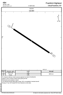


6B4 - Frankfort-Highland
Located in Utica/Frankfort, United States
ICAO - 6B4, IATA -
Data provided by AirmateGeneral information
Coordinates: N43°0'58" W75°10'10"
Elevation is 1325 feet MSL.
Magnetic variation is -13° East View others Airports in New York
Operational data
Special qualification required
Current time UTC:
Current local time:
Weather at : KRME - Griffiss Intl ( 31 km )
METAR: KRME 060053Z 08006KT 8SM OVC016 12/11 A3008 RMK AO2 SLP187 T01170111
TAF: KRME 052331Z 0600/0624 13006KT 6SM BR OVC018 FM060700 17004KT 2SM BR OVC009 FM060900 VRB03KT 1 1/2SM -SHRA BR OVC005 FM061430 26007KT P6SM FEW008 SCT012 BKN022 FM061800 27008G13KT P6SM SCT050
Communications frequencies: [VIEW]
Runways:
| RWY identifier | QFU | Length (ft) | Width (ft) | Surface | LDA (ft) |
| 13 | 123° | 2750 | 60 | ASPH | |
| 31 | 303° | 2750 | 60 | ASPH |
Airport contact information
Address: Utica/Frankfort United States