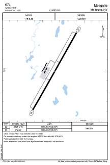


67L - Mesquite
Located in Mesquite, United States
ICAO - 67L, IATA -
Data provided by AirmateGeneral information
Coordinates: N36°49'59" W114°3'21"
Elevation is 1978 feet MSL.
Magnetic variation is 11° East View others Airports in Nevada
Operational data
Special qualification required
Current time UTC:
Current local time:
Weather at : KSGU - St George Rgnl ( 53 km )
METAR: KSGU 210256Z AUTO 18012KT 10SM CLR 23/02 A2975 RMK AO2 WSHFT 0207 SLP041 T02330017 53013
TAF: KSGU 210206Z 2102/2124 17011KT P6SM SCT120 FM210300 VRB05KT P6SM FEW150 FM210700 05015KT P6SM SKC FM211500 VRB05KT P6SM SKC FM212000 31009KT P6SM SKC
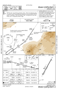
Communications frequencies: [VIEW]
Runways:
| RWY identifier | QFU | Length (ft) | Width (ft) | Surface | LDA (ft) |
| 02 | 29° | 5121 | 75 | ASPH | |
| 20 | 209° | 5121 | 75 | ASPH |
Airport contact information
Address: Mesquite United States