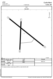


47V - Curtis Muni
Located in Curtis, United States
ICAO - 47V, IATA -
Data provided by AirmateGeneral information
Coordinates: N40°38'20" W100°28'24"
Elevation is 2677 feet MSL.
Magnetic variation is 06° East View others Airports in Nebraska
Operational data
Special qualification required
Current time UTC:
Current local time:
Communications frequencies: [VIEW]
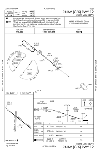
Runways:
| RWY identifier | QFU | Length (ft) | Width (ft) | Surface | LDA (ft) |
| 12 | 129° | 3402 | 60 | CONC | |
| 30 | 309° | 3402 | 60 | CONC | |
| 17 | 182° | 2200 | 120 | GRASS | |
| 35 | 2° | 2200 | 120 | GRASS |
Airport contact information
Address: Curtis United States