


41F - Floydada Muni
Located in Floydada, United States
ICAO - 41F, IATA -
Data provided by AirmateGeneral information
Coordinates: N34°0'6" W101°19'49"
Elevation is 3187 feet MSL.
Magnetic variation is 07° East View others Airports in Texas
Operational data
Special qualification required
Current time UTC:
Current local time:
Weather at : KPVW - Hale County ( 40 km )
METAR: KPVW 211610Z AUTO 30018G23KT 10SM CLR 26/M02 A2986 RMK AO2 T02571017
TAF: KPVW 211120Z 2112/2212 27011KT P6SM BKN250 FM211400 28016G26KT P6SM SCT250 FM220100 20011KT P6SM FEW250
Communications frequencies: [VIEW]
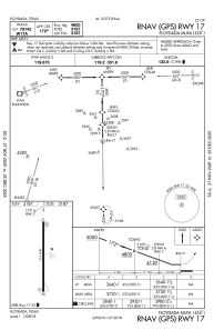
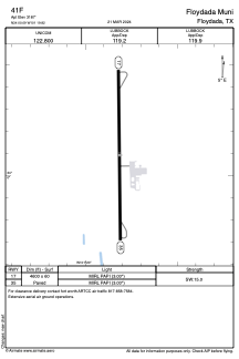
Runways:
| RWY identifier | QFU | Length (ft) | Width (ft) | Surface | LDA (ft) |
| 17 | 179° | 4600 | 60 | ASPH | |
| 35 | 359° | 4600 | 60 | ASPH |
Airport contact information
Address: Floydada United States