


3SD4 - Chris Hofer Landing Strip
Located in Tea, United States
ICAO - 3SD4, IATA -
Data provided by AirmateGeneral information
Coordinates: N43°27'55" W96°51'46"
Elevation is 1515 feet MSL.
View others Airports in South Dakota
Operational data
Special qualification required
Current time UTC:
Current local time:
Weather at : KFSD - Joe Foss Fld ( 16 km )
METAR: KFSD 210256Z 02008KT 10SM FEW034 BKN110 BKN250 18/13 A2978 RMK AO2 SLP079 60000 T01830133 58003
TAF: KFSD 202342Z 2100/2124 35008KT P6SM SCT045 SCT150 FM210030 02009KT P6SM -RA SCT045 OVC100 FM210500 03010KT 5SM SHRA BR VCTS BKN050CB TEMPO 2105/2109 5SM -TSRA BR FM211100 03012G19KT P6SM -SHRA VCTS SCT007 OVC015CB FM211500 04014G22KT 5SM -SHRA BR OVC007 FM211800 35013G24KT 5SM -RA BR OVC007 FM212100 30017G29KT P6SM OVC015
Communications frequencies: [VIEW]
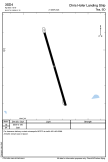
Runways:
| RWY identifier | QFU | Length (ft) | Width (ft) | Surface | LDA (ft) |
| 16 | 164° | 2300 | 120 | GRASS | |
| 34 | 344° | 2300 | 120 | GRASS |
Airport contact information
Address: Tea United States