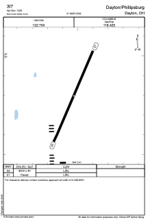


3I7 - Dayton/Phillipsburg
Located in Dayton, United States
ICAO - 3I7, IATA -
Data provided by AirmateGeneral information
Coordinates: N39°54'48" W84°24'1"
Elevation is 1028 feet MSL.
Magnetic variation is -04° East View others Airports in Ohio
Operational data
Special qualification required
Current time UTC:
Current local time:
Weather at : KDAY - James M Cox Dayton Intl ( 15 km )
METAR: KDAY 210156Z 18004KT 10SM SCT070 SCT250 26/16 A2994 RMK AO2 SLP127 T02560156
TAF: KDAY 202321Z 2100/2124 20008KT P6SM SCT050 SCT250 FM210200 20004KT P6SM FEW050 BKN250 FM211500 21010KT P6SM SCT040 SCT250 FM212300 19008KT P6SM FEW060
Communications frequencies: [VIEW]
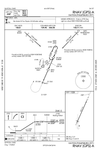
Runways:
| RWY identifier | QFU | Length (ft) | Width (ft) | Surface | LDA (ft) |
| 03 | 24° | 3000 | 40 | ASPH | |
| 21 | 204° | 3000 | 40 | ASPH |
Airport contact information
Address: Dayton United States
