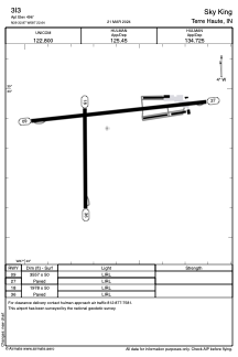


3I3 - Sky King
Located in Terre Haute, United States
ICAO - 3I3, IATA -
Data provided by AirmateGeneral information
Coordinates: N39°32'52" W87°22'38"
Elevation is 496 feet MSL.
Magnetic variation is -04° East View others Airports in Indiana
Operational data
Special qualification required
Current time UTC:
Current local time:
Weather at : KHUF - Terre Haute Rgnl ( 12 km )
METAR: KHUF 140053Z 18008KT 10SM CLR 23/13 A2977 RMK AO2 LTG DSNT NW SLP078 T02280133
Communications frequencies: [VIEW]
Runways:
| RWY identifier | QFU | Length (ft) | Width (ft) | Surface | LDA (ft) |
| 09 | 84° | 3557 | 50 | ASPH | |
| 27 | 264° | 3557 | 50 | ASPH | |
| 18 | 179° | 1978 | 50 | ASPH | |
| 36 | 359° | 1978 | 50 | ASPH |
Airport contact information
Address: Terre Haute United States
