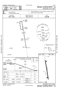
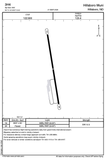


3H4 - Hillsboro Muni
Located in Hillsboro, United States
ICAO - 3H4, IATA -
Data provided by AirmateGeneral information
Coordinates: N47°21'34" W97°3'37"
Elevation is 906 feet MSL.
Magnetic variation is 05° East View others Airports in North Dakota
Operational data
Special qualification required
Current time UTC:
Current local time:
Weather at : KFAR - Hector Intl ( 52 km )
METAR: KFAR 212053Z 34019KT 4SM R36/4500VP6000FT RA OVC060 13/08 A2971 RMK AO2 SLP062 P0016 60024 T01280083 53009
TAF: KFAR 211726Z 2118/2218 02009KT P6SM -RA BKN070 FM211900 01016KT 4SM SHRA BR OVC040 FM212100 36023G32KT 3SM SHRA BR OVC035 FM212300 35023G34KT 4SM SHRA BR OVC040 FM220500 33020G27KT 6SM -SHRA BR BKN100 FM221500 30016KT P6SM FEW120
Communications frequencies: [VIEW]
Runways:
| RWY identifier | QFU | Length (ft) | Width (ft) | Surface | LDA (ft) |
| 16 | 171° | 3301 | 60 | CONC | |
| 34 | 351° | 3301 | 60 | CONC |
Airport contact information
Address: Hillsboro United States