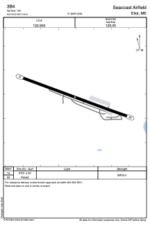


3B4 - Seacoast Airfield
Located in Eliot, United States
ICAO - 3B4, IATA -
Data provided by AirmateGeneral information
Coordinates: N43°8'35" W70°46'24"
Elevation is 125 feet MSL.
Magnetic variation is -16° East View others Airports in Maine
Operational data
Special qualification required
Current time UTC:
Current local time:
Weather at : KPSM - Portsmouth Intl At Pease ( 8 km )
METAR: KPSM 212255Z 10005KT 10SM -TSRA SCT030 OVC080 20/18 A2985 RMK AO2A LTG DSNT S-W-N SLP111 P0000 T02020179
TAF: KPSM 212334Z 2200/2224 19008KT P6SM -TSRA SCT030CB FM220030 19004KT P6SM BKN200 FM220600 VRB04KT 2SM BR FEW250 FM221200 23006KT P6SM BKN250
Communications frequencies: [VIEW]
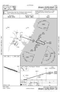
Runways:
| RWY identifier | QFU | Length (ft) | Width (ft) | Surface | LDA (ft) |
| 12 | 110° | 2701 | 50 | ASPH | |
| 30 | 290° | 2701 | 50 | ASPH |
Airport contact information
Address: Eliot United States