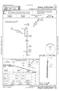
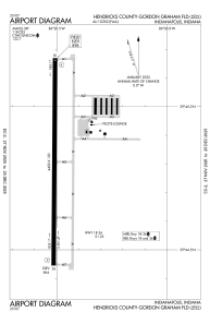


2R2 - Hendricks County-Gordon Graham Fld
Located in Indianapolis, United States
ICAO - 2R2, IATA -
Data provided by AirmateGeneral information
Coordinates: N39°44'48" W86°28'31"
Elevation is 898 feet MSL.
Magnetic variation is -03° East View others Airports in Indiana
Operational data
Special qualification required
Current time UTC:
Current local time:
Weather at : KIND - Indianapolis Intl ( 16 km )
METAR: KIND 181300Z 00000KT 2SM R05L/2000V5500FT BR OVC002 17/17 A2992 RMK AO2 T01720172
TAF: KIND 181120Z 1812/1918 16003KT 1SM BR BKN002 TEMPO 1812/1813 1/4SM FG FM181300 16003KT 3SM BR BCFG BKN005 FM181400 16003KT P6SM BKN019 FM181500 16005KT P6SM SCT025 FM190000 22005KT P6SM SCT250
Communications frequencies: [VIEW]
Runways:
| RWY identifier | QFU | Length (ft) | Width (ft) | Surface | LDA (ft) |
| 18 | 180° | 4400 | 100 | ASPH | |
| 36 | 0° | 4400 | 100 | ASPH |
Airport contact information
Address: Indianapolis United States
