


26A - Ashland/Lineville
Located in Ashland/Lineville, United States
ICAO - 26A, IATA -
Data provided by AirmateGeneral information
Coordinates: N33°17'3" W85°48'32"
Elevation is 1065 feet MSL.
Magnetic variation is -01° East View others Airports in Alabama
Operational data
Special qualification required
Current time UTC:
Current local time:
Weather at : KANB - Anniston Rgnl ( 34 km )
METAR: KANB 171611Z AUTO 15003KT 10SM FEW021 SCT028 OVC035 21/18 A2987 RMK AO2 RAE05 P0000 T02060183
TAF: KANB 171458Z 1715/1812 15005KT 6SM SHRA BR OVC040 FM171800 14007KT 5SM SHRA BR BKN025 TEMPO 1718/1720 4SM TSRA BR OVC011CB FM180000 17005KT P6SM BKN010 FM180500 VRB03KT 5SM BR OVC008 PROB30 1805/1811 2SM TSRA BR OVC005CB
Communications frequencies: [VIEW]
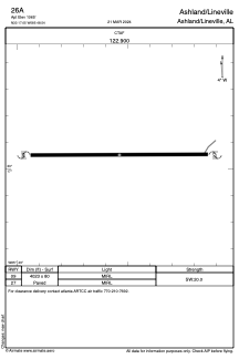
Runways:
| RWY identifier | QFU | Length (ft) | Width (ft) | Surface | LDA (ft) |
| 09 | 0° | 4023 | 80 | ASPH | |
| 27 | 0° | 4023 | 80 | ASPH |
Airport contact information
Address: Ashland/Lineville United States