


24C - Lowell City
Located in Lowell, United States
ICAO - 24C, IATA -
Data provided by AirmateGeneral information
Coordinates: N42°57'17" W85°20'44"
Elevation is 681 feet MSL.
Magnetic variation is -04° East View others Airports in Michigan
Operational data
Special qualification required
Current time UTC:
Current local time:
Weather at : KGRR - Gerald R Ford Intl ( 17 km )
METAR: KGRR 171753Z 24005KT 10SM FEW031 SCT043 SCT075 24/17 A2979 RMK AO2 SLP083 T02440172 10244 20183 56011
TAF: KGRR 171740Z 1718/1818 25006KT P6SM SCT025 FM171900 25006KT P6SM SCT250 FM180600 00000KT 2SM BR SKC FM181400 18004KT P6SM FEW250
Communications frequencies: [VIEW]
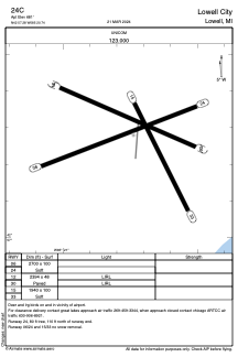
Runways:
| RWY identifier | QFU | Length (ft) | Width (ft) | Surface | LDA (ft) |
| 06 | 69° | 2700 | 100 | GRASS | |
| 24 | 249° | 2700 | 100 | GRASS | |
| 12 | 0° | 2394 | 48 | ASPH | |
| 30 | 0° | 2394 | 48 | ASPH | |
| 15 | 153° | 1940 | 100 | GRASS | |
| 33 | 333° | 1940 | 100 | GRASS |
Airport contact information
Address: Lowell United States
