


22M - Pontotoc County
Located in Pontotoc, United States
ICAO - 22M, IATA -
Data provided by AirmateGeneral information
Coordinates: N34°16'32" W89°2'17"
Elevation is 440 feet MSL.
Magnetic variation is 02° East View others Airports in Mississippi
Operational data
Special qualification required
Current time UTC:
Current local time:
Weather at : KTUP - Tupelo Rgnl ( 25 km )
METAR: KTUP 071408Z 19012G20KT 10SM BKN017 BKN023 BKN060 25/22 A2983 RMK AO2 T02500217
TAF: KTUP 071121Z 0712/0812 18008KT P6SM SCT015 OVC250 TEMPO 0712/0713 BKN015 FM071300 19011G17KT P6SM VCSH OVC020 FM071800 20012G18KT P6SM VCSH BKN040 FM080000 18007KT P6SM SCT050 BKN100 FM080900 18007KT P6SM OVC015
Communications frequencies: [VIEW]
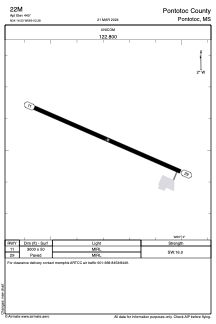
Runways:
| RWY identifier | QFU | Length (ft) | Width (ft) | Surface | LDA (ft) |
| 11 | 113° | 3000 | 50 | ASPH | |
| 29 | 293° | 3000 | 50 | ASPH |
Airport contact information
Address: Pontotoc United States