


21ND - Rosenau
Located in Upham, United States
ICAO - 21ND, IATA -
Data provided by AirmateGeneral information
Coordinates: N48°34'56" W100°51'17"
Elevation is 1450 feet MSL.
Magnetic variation is 10° East View others Airports in North Dakota
Operational data
Special qualification required
Current time UTC:
Current local time:
Weather at : KMIB - Minot Afb ( 41 km )
METAR: KMIB 020855Z 21005KT 10SM OVC060 06/04 A2982 RMK AO2A SLP109 T00640039 58002
TAF: TAF KMIB 020900Z 0209/0315 21009KT 9999 BKN040 BKN080 610505 QNH2980INS BECMG 0211/0212 16009KT 9999 BKN030 BKN080 610505 QNH2974INS BECMG 0214/0215 14009KT 9999 BKN025 BKN080 610505 QNH2968INS BECMG 0219/0220 11012KT 8000 -SHRA BKN020 OVC060 610505 QNH2966INS TEMPO 0222/0301 09012G20KT 4800 -TSRA OVC020CB BECMG 0305/0306 VRB06KT 9999 NSW OVC015 610505 QNH2966INS BECMG 0313/0314 30012G18KT 8000 -SHRA OVC015 610505 QNH2974INS TX12/0221Z TN05/0309Z
Communications frequencies: [VIEW]
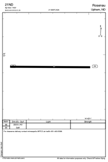
Runways:
| RWY identifier | QFU | Length (ft) | Width (ft) | Surface | LDA (ft) |
| 08 | 90° | 2500 | 40 | GRASS | |
| 26 | 270° | 2500 | 40 | GRASS |
Airport contact information
Address: Upham United States