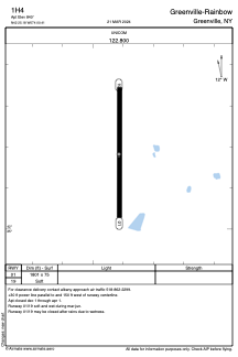


1H4 - Greenville-Rainbow
Located in Greenville, United States
ICAO - 1H4, IATA -
Data provided by AirmateGeneral information
Coordinates: N42°25'11" W74°0'25"
Elevation is 840 feet MSL.
Magnetic variation is -14° East View others Airports in New York
Operational data
Special qualification required
Current time UTC:
Current local time:
Weather at : KALB - Albany Intl ( 40 km )
METAR: KALB 120051Z 16005KT 10SM OVC075 15/04 A2980 RMK AO2 SLP090 T01500044
TAF: KALB 112323Z 1200/1224 14009KT P6SM VCSH BKN045 TEMPO 1204/1207 16010G18KT 4SM -SHRA BR BKN028 FM120700 16008G17KT 4SM -SHRA BR BKN025 FM121200 16007KT P6SM VCSH FEW018 BKN022 PROB30 1212/1217 4SM -SHRA BR OVC018 FM121700 15007KT P6SM VCSH SCT025 BKN040
Communications frequencies: [VIEW]
Runways:
| RWY identifier | QFU | Length (ft) | Width (ft) | Surface | LDA (ft) |
| 01 | 360° | 1801 | 75 | GRASS | |
| 19 | 180° | 1801 | 75 | GRASS |
Airport contact information
Address: Greenville United States