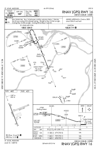
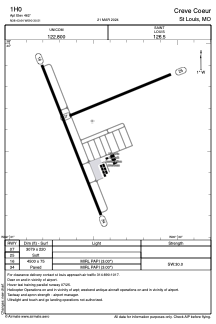


1H0 - Creve Coeur
Located in St Louis, United States
ICAO - 1H0, IATA -
Data provided by AirmateGeneral information
Coordinates: N38°43'38" W90°30'30"
Elevation is 462 feet MSL.
Magnetic variation is 00° East View others Airports in Missouri
Operational data
Special qualification required
Current time UTC:
Current local time:
Weather at : KSTL - St Louis Lambert Intl ( 12 km )
METAR: KSTL 261451Z 17024G36KT 10SM -RA SCT110 BKN250 22/17 A2953 RMK AO2 PK WND 17036/1448 RAE07B42 SLP988 P0000 60021 T02170167 58056 $
TAF: KSTL 261407Z 2614/2718 17011KT P6SM VCSH SCT025 OVC090 FM261700 19012G21KT P6SM BKN035 FM262000 20012G20KT P6SM VCTS SCT050CB BKN250 FM270400 29007KT P6SM BKN015 FM271000 30009KT P6SM SCT030
Communications frequencies: [VIEW]
Runways:
| RWY identifier | QFU | Length (ft) | Width (ft) | Surface | LDA (ft) |
| 07 | 68° | 3079 | 220 | GRASS | |
| 25 | 248° | 3079 | 220 | GRASS | |
| 16 | 158° | 4500 | 75 | CONC | |
| 34 | 338° | 4500 | 75 | CONC |
Airport contact information
Address: St Louis United States
