


1A2 - Arthur
Located in Arthur, United States
ICAO - 1A2, IATA -
Data provided by AirmateGeneral information
Coordinates: N47°6'45" W97°12'29"
Elevation is 973 feet MSL.
Magnetic variation is 06° East View others Airports in North Dakota
Operational data
Special qualification required
Current time UTC:
Current local time:
Weather at : KFAR - Hector Intl ( 37 km )
METAR: KFAR 211053Z 02006KT 10SM CLR 13/09 A2980 RMK AO2 SLP090 T01280089
TAF: KFAR 210520Z 2106/2206 00000KT P6SM FEW120 FM211300 05007KT 6SM BR VCSH OVC080 FM211600 04013KT 6SM -SHRA OVC040 FM220400 34018G25KT 6SM -SHRA BR OVC060
Communications frequencies: [VIEW]
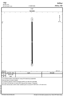
Runways:
| RWY identifier | QFU | Length (ft) | Width (ft) | Surface | LDA (ft) |
| 17 | 180° | 3100 | 85 | GRASS | |
| 35 | 0° | 3100 | 85 | GRASS |
Airport contact information
Address: Arthur United States