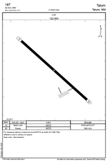


18T - Tatum
Located in Tatum, United States
ICAO - 18T, IATA -
Data provided by AirmateGeneral information
Coordinates: N33°15'39" W103°16'43"
Elevation is 3986 feet MSL.
Magnetic variation is 10° East View others Airports in New Mexico
Operational data
Special qualification required
Current time UTC:
Current local time:
Weather at : KHOB - Lea County Rgnl ( 64 km )
METAR: KHOB 211750Z 22015KT 10SM CLR 28/M03 A2992
TAF: KHOB 211723Z 2118/2218 24015G22KT P6SM BKN250 FM220100 23010KT P6SM FEW250 FM221000 02011KT P6SM SKC
Communications frequencies: [VIEW]
Runways:
| RWY identifier | QFU | Length (ft) | Width (ft) | Surface | LDA (ft) |
| 12 | 132° | 2920 | 60 | ASPH | |
| 30 | 312° | 2920 | 60 | ASPH |
Airport contact information
Address: Tatum United States