


17M - Magee Muni
Located in Magee, United States
ICAO - 17M, IATA -
Data provided by AirmateGeneral information
Coordinates: N31°51'46" W89°48'2"
Elevation is 556 feet MSL.
Magnetic variation is -01° East View others Airports in Mississippi
Operational data
Special qualification required
Current time UTC:
Current local time:
Weather at : KJAN - Jackson-Medgar Wiley Evers Intl ( 56 km )
METAR: KJAN 171254Z 13003KT 6SM -RA BR FEW019 FEW027 OVC044 21/19 A2977 RMK AO2 LTG DSNT E-S RAE20B44 SLP075 P0000 T02060194
TAF: KJAN 171220Z 1712/1812 VRB05KT 4SM -RA BR BKN015 OVC025 TEMPO 1712/1714 TSRA BKN015CB OVC025 FM171500 18008KT 6SM BR VCSH BKN007 OVC012 FM171900 20006KT P6SM SCT015 BKN025 FM172300 VRB03KT P6SM FEW025 SCT150
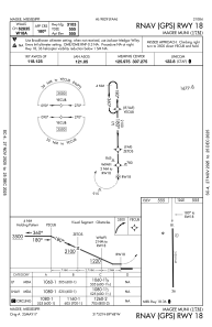
Communications frequencies: [VIEW]
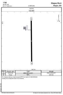
Runways:
| RWY identifier | QFU | Length (ft) | Width (ft) | Surface | LDA (ft) |
| 18 | 179° | 3103 | 60 | ASPH | |
| 36 | 359° | 3103 | 60 | ASPH |
Airport contact information
Address: Magee United States