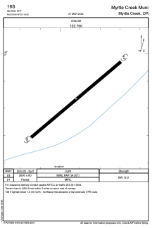


16S - Myrtle Creek Muni
Located in Myrtle Creek, United States
ICAO - 16S, IATA -
Data provided by AirmateGeneral information
Coordinates: N42°59'50" W123°18'55"
Elevation is 619 feet MSL.
Magnetic variation is 18° East View others Airports in Oregon
Operational data
Special qualification required
Current time UTC:
Current local time:
Weather at : KRBG - Roseburg Rgnl ( 27 km )
METAR: KRBG 211453Z AUTO 00000KT 10SM CLR 10/06 A3022 RMK AO2 SLP232 T01000056 50001
TAF: KRBG 211128Z 2112/2212 00000KT P6SM SKC FM212300 32007KT P6SM BKN250 FM220500 VRB03KT P6SM -SHRA OVC020
Communications frequencies: [VIEW]
Runways:
| RWY identifier | QFU | Length (ft) | Width (ft) | Surface | LDA (ft) |
| 03 | 0° | 2600 | 60 | ASPH | |
| 21 | 0° | 2600 | 60 | ASPH |
Airport contact information
Address: Myrtle Creek United States