


12Y - Le Sueur Muni
Located in Le Sueur, United States
ICAO - 12Y, IATA -
Data provided by AirmateGeneral information
Coordinates: N44°26'27" W93°54'57"
Elevation is 868 feet MSL.
Magnetic variation is 04° East View others Airports in Minnesota
Operational data
Special qualification required
Current time UTC:
Current local time:
Weather at : KMKT - Mankato Rgnl ( 24 km )
METAR: KMKT 210756Z AUTO 00000KT 10SM -RA OVC110 19/17 A2972 RMK AO2 RAB47 SLP062 T01890172 PNO $
TAF: KMKT 210520Z 2106/2206 06008KT 6SM -RA SCT025 OVC040 TEMPO 2106/2110 4SM -TSRA BR OVC025CB FM211300 13015G25KT 4SM -RA BR OVC010 TEMPO 2118/2122 2SM -TSRA BR OVC007CB FM212300 29014G22KT 3SM -RA BR OVC007
Communications frequencies: [VIEW]
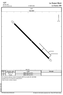
Runways:
| RWY identifier | QFU | Length (ft) | Width (ft) | Surface | LDA (ft) |
| 13 | 135° | 3000 | 75 | ASPH | |
| 31 | 315° | 3000 | 75 | ASPH |
Airport contact information
Address: Le Sueur United States