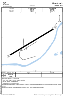


12V - Ona Airpark
Located in Milton, United States
ICAO - 12V, IATA -
Data provided by AirmateGeneral information
Coordinates: N38°26'27" W82°12'3"
Elevation is 572 feet MSL.
Magnetic variation is -06° East View others Airports in West Virginia
Operational data
Special qualification required
Current time UTC:
Current local time:
Weather at : KHTS - Tri-State/Milton J Ferguson Fld ( 32 km )
METAR: KHTS 281351Z 20007KT 10SM CLR 22/12 A3020 RMK AO2 SLP220 T02220117
TAF: KHTS 281120Z 2812/2912 19004KT P6SM FEW250 WS020/22035KT FM281400 22005KT P6SM SKC FM290000 21004KT P6SM SKC
Communications frequencies: [VIEW]
Runways:
| RWY identifier | QFU | Length (ft) | Width (ft) | Surface | LDA (ft) |
| 07 | 59° | 3154 | 40 | ASPH | |
| 25 | 239° | 3154 | 40 | ASPH |
Airport contact information
Address: Milton United States
