


0S0 - Lind
Located in Lind, United States
ICAO - 0S0, IATA -
Data provided by AirmateGeneral information
Coordinates: N46°58'37" W118°35'14"
Elevation is 1507 feet MSL.
Magnetic variation is 19° East View others Airports in Washington
Operational data
Special qualification required
Current time UTC:
Current local time:
Weather at : KMWH - Grant County Intl ( 61 km )
METAR: KMWH 170452Z AUTO 27024G38KT 10SM BLDU CLR 17/01 A2971 RMK AO2 PK WND 27041/0423 SLP055 T01670011 $
TAF: KMWH 170520Z 1706/1806 26025G39KT P6SM SCT250 FM171000 26020G29KT P6SM FEW250 FM171600 26023G33KT P6SM FEW100 FM172100 25016G22KT P6SM SCT200 FM180300 29014KT P6SM SCT250
Communications frequencies: [VIEW]
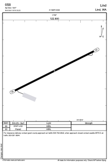
Runways:
| RWY identifier | QFU | Length (ft) | Width (ft) | Surface | LDA (ft) |
| 05 | 64° | 3197 | 50 | ASPH | |
| 23 | 244° | 3197 | 50 | ASPH |
Airport contact information
Address: Lind United States