


0PA3 - Robbins Farm
Located in Troy, United States
ICAO - 0PA3, IATA -
Data provided by AirmateGeneral information
Coordinates: N41°44'50" W76°45'37"
Elevation is 1455 feet MSL.
Magnetic variation is -11° East View others Airports in Pennsylvania
Operational data
Special qualification required
Current time UTC:
Current local time:
Weather at : KELM - Elmira/Corning Rgnl ( 47 km )
METAR: KELM 212053Z 20009KT 10SM SCT085 SCT110 32/13 A2987 RMK AO2 SLP109 T03170128 56010
TAF: KELM 211721Z 2118/2218 23008G15KT P6SM FEW080 SCT200 FM220200 VRB03KT P6SM FEW250 FM221600 22007G14KT P6SM FEW200
Communications frequencies: [VIEW]
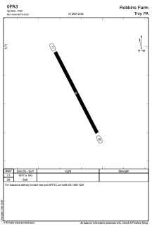
Runways:
| RWY identifier | QFU | Length (ft) | Width (ft) | Surface | LDA (ft) |
| 17 | 153° | 1977 | 100 | GRASS | |
| 35 | 333° | 1977 | 100 | GRASS |
Airport contact information
Address: Troy United States