


0O4 - Corning Muni
Located in Corning, United States
ICAO - 0O4, IATA -
Data provided by AirmateGeneral information
Coordinates: N39°56'46" W122°10'16"
Elevation is 295 feet MSL.
Magnetic variation is 17° East View others Airports in California
Operational data
Special qualification required
Current time UTC:
Current local time:
Weather at : KRBL - Red Bluff Muni ( 24 km )
METAR: KRBL 231154Z AUTO 14007KT 10SM CLR 14/11 A2981 RMK AO2 SLP093 T01440111 10167 20144 51014
TAF: KRBL 231120Z 2312/2412 15006KT P6SM BKN120 FM240000 17009KT P6SM VCSH BKN070
Communications frequencies: [VIEW]
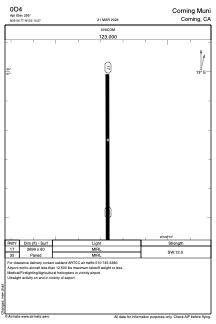
Runways:
| RWY identifier | QFU | Length (ft) | Width (ft) | Surface | LDA (ft) |
| 17 | 180° | 2699 | 60 | ASPH | |
| 35 | 360° | 2699 | 60 | ASPH |
Airport contact information
Address: Corning United States