


0K7 - Humboldt Muni
Located in Humboldt, United States
ICAO - 0K7, IATA -
Data provided by AirmateGeneral information
Coordinates: N42°44'5" W94°14'44"
Elevation is 1098 feet MSL.
Magnetic variation is 04° East View others Airports in Iowa
Operational data
Special qualification required
Current time UTC:
Current local time:
Weather at : KFOD - Fort Dodge Rgnl ( 21 km )
METAR: KFOD 261456Z AUTO 13012G22KT 10SM -RA OVC010 09/07 A2969 RMK AO2 SLP069 P0000 60002 T00890072 58020
TAF: KFOD 261129Z 2612/2712 13019G30KT 6SM -SHRA VCTS OVC025CB FM261500 13021G33KT 4SM SHRA VCTS OVC007CB FM261900 13020G33KT P6SM OVC007 FM270100 15020G32KT 4SM TSRA OVC007CB FM270400 16018G29KT P6SM BKN015 FM270600 19017G28KT P6SM BKN040
Communications frequencies: [VIEW]
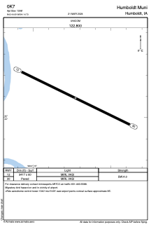
Runways:
| RWY identifier | QFU | Length (ft) | Width (ft) | Surface | LDA (ft) |
| 12 | 116° | 3417 | 60 | ASPH | |
| 30 | 296° | 3417 | 60 | ASPH |
Airport contact information
Address: Humboldt United States