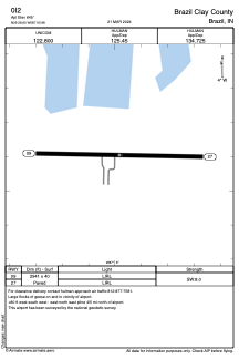


0I2 - Brazil Clay County
Located in Brazil, United States
ICAO - 0I2, IATA -
Data provided by AirmateGeneral information
Coordinates: N39°28'36" W87°5'59"
Elevation is 645 feet MSL.
Magnetic variation is -04° East View others Airports in Indiana
Operational data
Special qualification required
Current time UTC:
Current local time:
Weather at : KHUF - Terre Haute Rgnl ( 18 km )
TAF: KHUF 211120Z 2112/2212 18004KT P6SM FEW230 FM211400 19010G17KT P6SM FEW250 FM211800 19015G25KT P6SM SCT060 FM220500 20011G21KT P6SM VCSH OVC060
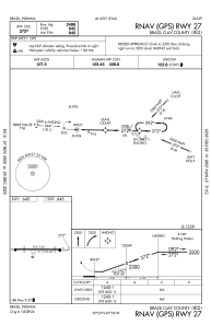
Communications frequencies: [VIEW]
Runways:
| RWY identifier | QFU | Length (ft) | Width (ft) | Surface | LDA (ft) |
| 09 | 91° | 2941 | 40 | ASPH | |
| 27 | 271° | 2941 | 40 | ASPH |
Airport contact information
Address: Brazil United States