


00IG - Goltl
Located in Mcdonald, United States
ICAO - 00IG, IATA -
Data provided by AirmateGeneral information
Coordinates: N39°43'27" W101°23'46"
Elevation is 3359 feet MSL.
View others Airports in Kansas
Operational data
Special qualification required
Current time UTC:
Current local time:
Weather at : KSYF - Cheyenne County Muni ( 34 km )
METAR: KSYF 210415Z AUTO 09019KT 9SM BKN008 BKN013 BKN047 19/17 A2959 RMK AO2 PRESFR
Communications frequencies: [VIEW]
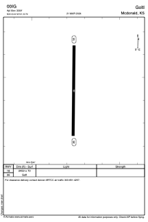
Runways:
| RWY identifier | QFU | Length (ft) | Width (ft) | Surface | LDA (ft) |
| 18 | 0° | 2450 | 70 | GRASS | |
| 36 | 0° | 2450 | 70 | GRASS |
Airport contact information
Address: Mcdonald United States