


YGNE - Gnarwarre
Located in Gnarwarre, Australia
ICAO - , IATA -
Data provided by AirmateGeneral information
Coordinates: S38°9'54" E144°6'27"
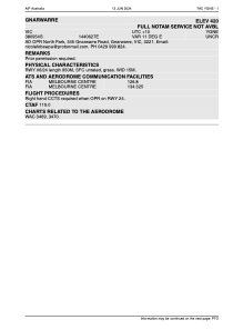
Elevation is 420 feet MSL.
Magnetic variation is 11° East View others Airports in Victoria
Operational data
Special qualification required
Current time UTC:
Current local time:
Communications frequencies: [VIEW]
Runways:
| RWY identifier | QFU | Length (ft) | Width (ft) | Surface | LDA (ft) |
| 06 | 0° | 3117 | 49 | UNK | |
| 24 | 0° | 3117 | 49 | UNK |
Airport contact information
Address: Gnarwarre Australia