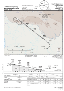
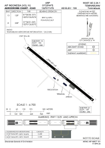


WAST - Teminabuan / Teminabuan
Located in Teminabuan, Indonesia
ICAO - WAST, IATA - TXM
Data provided by AirmateGeneral information
Coordinates: S1°26'40" E132°1'12"
Elevation is 144 feet MSL.
Magnetic variation is 1° East View others Airports in Irian Jaya
Operational data
Special qualification required
Current time UTC:
Current local time:
Communications frequencies: [VIEW]
Runways:
| RWY identifier | QFU | Length (ft) | Width (ft) | Surface | LDA (ft) |
| 13 | 129° | 2625 | 75 | UNK | |
| 31 | 309° | 2625 | 75 | UNK |
Airport contact information
Address: Teminabuan Indonesia