


W42 - Fallston
Located in Fallston, United States
ICAO - W42, IATA -
Data provided by AirmateGeneral information
Coordinates: N39°30'5" W76°24'41"
Elevation is 460 feet MSL.
Magnetic variation is -10° East View others Airports in Maryland
Operational data
Special qualification required
Current time UTC:
Current local time:
Weather at : KMTN - Martin State ( 20 km )
METAR: KMTN 122154Z 14009KT 10SM SCT065 25/15 A3001
TAF: KMTN 121726Z 1218/1318 12006KT P6SM SCT060 BKN250 FM130200 15003KT P6SM SCT060 FM131400 17008G15KT P6SM SCT060
Communications frequencies: [VIEW]
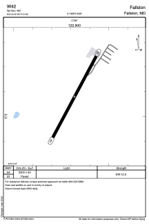
Runways:
| RWY identifier | QFU | Length (ft) | Width (ft) | Surface | LDA (ft) |
| 04 | 28° | 2200 | 50 | ASPH | |
| 22 | 208° | 2200 | 50 | ASPH |
Airport contact information
Address: Fallston United States