logo
Search for airport 
image banner adimage banner adimage banner ad
image banner ad

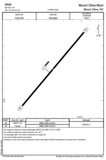
W40 - Mount Olive Muni

Located in Mount Olive, United States

ICAO - W40, IATA -

Data provided by Airmate  

General information

Coordinates: N35°13'17" W78°2'19"
Elevation is 167 feet MSL.
Magnetic variation is -09° East
View others Airports in North Carolina

Operational data

Special qualification required
Current time UTC:
Current local time:
Weather at : KGSB - Seymour Johnson Afb ( 15 km )
METAR: KGSB 030955Z 23003KT 10SM BKN065 22/17 A3001 RMK AO2A SLP165 T02180174 RWY08 $
TAF: TAF KGSB 030400Z 0304/0410 18006KT 9999 FEW025 SCT040 QNH3001INS TEMPO 0311/0315 25010G15KT 9000 -SHRA SCT015 BKN025 BECMG 0316/0317 25012KT 9999 SCT020 OVC025 QNH2996INS TEMPO 0318/0323 26015G25KT 6000 -TSRA BKN025CB BECMG 0406/0407 21006KT 8000 BR FEW015 OVC040 QNH2990INS TX28/0320Z TN19/0308Z
View NOTAMs / SUP AIP / TFR affecting this airport [VIEW]
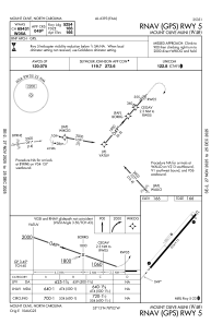
Communications frequencies: [VIEW]

Runways:

RWY identifierQFULength (ft)Width (ft)SurfaceLDA (ft)
0540°525475ASPH
23220°525475ASPH

Airport contact information

Address: Mount Olive United States

Other aviation service providers

Flight schools

Bass Aviation, Inc.

Bass Aviation, Inc.
bassaviation@att.net+1(919)635-1471

Satellite view of W40