


W20 - Moses Lake Muni
Located in Moses Lake, United States
ICAO - W20, IATA -
Data provided by AirmateGeneral information
Coordinates: N47°8'31" W119°14'16"
Elevation is 1205 feet MSL.
Magnetic variation is 19° East View others Airports in Washington
Operational data
Special qualification required
Current time UTC:
Current local time:
Weather at : KMWH - Grant County Intl ( 10 km )
METAR: KMWH 291052Z AUTO 23010KT 10SM CLR 09/03 A3011 RMK AO2 SLP196 T00890028
TAF: KMWH 290523Z 2906/3006 25010KT P6SM FEW250 FM291700 26011KT P6SM SCT070 FM291900 26016G24KT P6SM SCT070 BKN100 PROB30 2919/2923 -SHRA FM292300 28017G26KT P6SM SCT090 FM300300 28013KT P6SM FEW250
Communications frequencies: [VIEW]
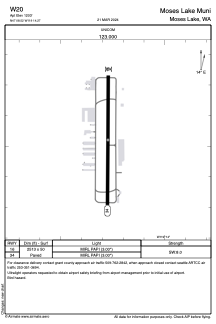
Runways:
| RWY identifier | QFU | Length (ft) | Width (ft) | Surface | LDA (ft) |
| 16 | 0° | 2513 | 50 | ASPH | |
| 34 | 0° | 2513 | 50 | ASPH |
Airport contact information
Address: Moses Lake United States
