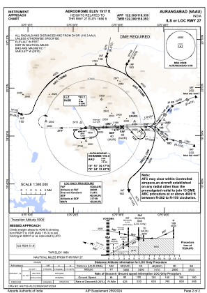


VAAU - Aurangabad Airport, Aurangabad
Located in Aurangabad, India
ICAO - VAAU, IATA - IXU
Data provided by AirmateGeneral information
Coordinates: N19°51'52" E75°23'51"
Elevation is 1917 feet MSL.
View others Airports in Maharashtra
Operational data
Special qualification required
Current time UTC:
Current local time:
Weather
METAR: VAAU 031200Z 20004KT 5000 HZ FEW020 SCT025 FEW025TCU 37/22 Q1006 NOSIG
TAF: TAF VAAU 030800Z 0309/0318 24010KT 5000 HZ FEW020 SCT025 TEMPO 0309/0315 29010G20KT 2000 -TSRA -SHRA SCT015 FEW030CB BKN090 BECMG 0315/0317 29008KT 3000 -RA DZ SCT018 SCT025 BKN090
Communications frequencies: [VIEW]
Runways:
| RWY identifier | QFU | Length (ft) | Width (ft) | Surface | LDA (ft) |
| 09 | 89° | 9314 | 148 | PEM | |
| 27 | 269° | 9314 | 148 | PEM |
Airport contact information
Address: Aurangabad India