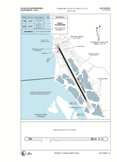


SESV - San Vicente / Los Perales
Located in San Vicente, Ecuador
ICAO - SESV, IATA - BHA
Data provided by AirmateGeneral information
Coordinates: S0°36'28" W80°24'10"
Elevation is 10 feet MSL.
Magnetic variation is -3° East View others Airports in Manabi
Operational data
Special qualification required
Current time UTC:
Current local time:
Communications frequencies: [VIEW]
Runways:
| RWY identifier | QFU | Length (ft) | Width (ft) | Surface | LDA (ft) |
| 15 | 151° | 6773 | 94 | ASPH | 6755 |
| 33 | 331° | 6773 | 94 | ASPH | 5771 |
Airport contact information
Address: San Vicente Ecuador