


S68 - Orofino Muni
Located in Orofino, United States
ICAO - S68, IATA -
Data provided by AirmateGeneral information
Coordinates: N46°29'31" W116°16'31"
Elevation is 1005 feet MSL.
Magnetic variation is 18° East View others Airports in Idaho
Operational data
Special qualification required
Current time UTC:
Current local time:
Weather at : KLWS - Lewiston/Nez Perce County ( 58 km )
METAR: KLWS 290156Z 29009G17KT 10SM OVC085 21/04 A2996 RMK AO2 PK WND 29031/0103 SLP140 T02110044
TAF: KLWS 282320Z 2900/2924 30017G32KT P6SM VCTS BKN090CB TEMPO 2900/2903 6SM -TSRA BKN050CB FM290300 27012KT P6SM OVC060 FM291200 28009KT P6SM SCT060 FM291900 28013KT P6SM SCT250
Communications frequencies: [VIEW]
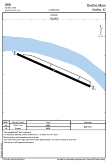
Runways:
| RWY identifier | QFU | Length (ft) | Width (ft) | Surface | LDA (ft) |
| 08 | 0° | 2520 | 60 | ASPH | |
| 26 | 0° | 2520 | 60 | ASPH |
Airport contact information
Address: Orofino United States