


S20 - Goldendale
Located in Goldendale, United States
ICAO - S20, IATA -
Data provided by AirmateGeneral information
Coordinates: N45°49'55" W120°50'43"
Elevation is 1678 feet MSL.
Magnetic variation is 19° East View others Airports in Washington
Operational data
Special qualification required
Current time UTC:
Current local time:
Weather at : KDLS - Columbia Gorge Rgnl/The Dalles Muni ( 34 km )
METAR: KDLS 010253Z AUTO 00000KT 10SM CLR 26/01 A2990 RMK AO2 SLP122 T02560011 56018
TAF: KDLS 312323Z 0100/0124 VRB06KT P6SM SCT250 FM010400 31006KT P6SM BKN250 FM011600 30016G26KT P6SM OVC100
Communications frequencies: [VIEW]
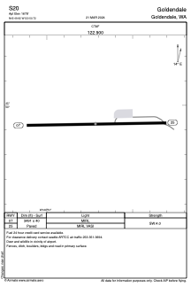
Runways:
| RWY identifier | QFU | Length (ft) | Width (ft) | Surface | LDA (ft) |
| 07 | 89° | 3491 | 40 | ASPH | |
| 25 | 269° | 3491 | 40 | ASPH |
Airport contact information
Address: Goldendale United States