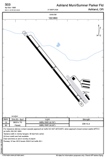


S03 - Ashland Muni/Sumner Parker Fld
Located in Ashland, United States
ICAO - S03, IATA -
Data provided by AirmateGeneral information
Coordinates: N42°11'25" W122°39'38"
Elevation is 1889 feet MSL.
Magnetic variation is 18° East View others Airports in Oregon
Operational data
Special qualification required
Current time UTC:
Current local time:
Communications frequencies: [VIEW]
Runways:
| RWY identifier | QFU | Length (ft) | Width (ft) | Surface | LDA (ft) |
| 12 | 141° | 3603 | 75 | ASPH | |
| 30 | 321° | 3603 | 75 | ASPH |
Airport contact information
Address: Ashland United States
