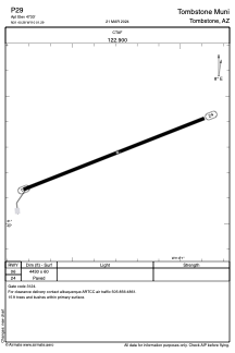


P29 - Tombstone Muni
Located in Tombstone, United States
ICAO - P29, IATA -
Data provided by AirmateGeneral information
Coordinates: N31°40'17" W110°1'17"
Elevation is 4733 feet MSL.
Magnetic variation is 10° East View others Airports in Arizona
Operational data
Special qualification required
Current time UTC:
Current local time:
Communications frequencies: [VIEW]
Runways:
| RWY identifier | QFU | Length (ft) | Width (ft) | Surface | LDA (ft) |
| 06 | 69° | 4430 | 60 | ASPH | |
| 24 | 249° | 4430 | 60 | ASPH |
Airport contact information
Address: Tombstone United States