


OH71 - Troy Skypark
Located in Troy, United States
ICAO - OH71, IATA -
Data provided by AirmateGeneral information
Coordinates: N39°59'26" W84°16'15"
Elevation is 930 feet MSL.
Magnetic variation is -04° East View others Airports in Ohio
Operational data
Special qualification required
Current time UTC:
Current local time:
Weather at : KDAY - James M Cox Dayton Intl ( 11 km )
METAR: KDAY 042338Z 24010KT 4SM -RA SCT070 BKN090 OVC220 22/19 A2982 RMK AO2 PK WND 21029/2307 LTG DSNT SE P0008 T02170194
TAF: KDAY 042339Z 0500/0524 18007KT P6SM SCT040 BKN250 FM050200 16005KT P6SM SCT040 BKN100 FM051000 18009KT P6SM VCSH SCT015 BKN025 FM051200 19011KT P6SM SCT008 BKN015 FM051400 20012G20KT P6SM VCSH BKN015 FM051700 21013G23KT P6SM -SHRA VCTS OVC025CB
Communications frequencies: [VIEW]
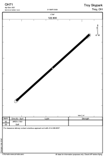
Runways:
| RWY identifier | QFU | Length (ft) | Width (ft) | Surface | LDA (ft) |
| 05 | 48° | 3450 | 100 | GRASS | |
| 23 | 228° | 3450 | 100 | GRASS |
Airport contact information
Address: Troy United States