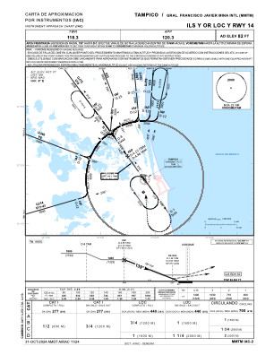
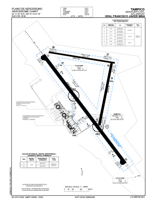


MMTM - Tampico Aeropuerto Internacional Gral. Francisco Javier Mina
Located in Tampico, Mexico
ICAO - MMTM, IATA - TAM
Data provided by AirmateGeneral information
Coordinates: N22°17'23" W97°51'52"
Elevation is 80 feet MSL.
View others Airports in Tamaulipas
Operational data
Special qualification required
Current time UTC:
Current local time:
Weather
METAR: MMTM 041849Z E12018KT 3SM HZ BKN200 34/25 A2967 RMK 8/008
TAF: TAF MMTM 041633Z 0418/0518 12010KT 4SM HZ SCT015 FM050200 13005KT 3SM BR HZ BKN012 TEMPO 0511/0515 2SM BR HZ OVC010 FM051600 13008KT 5SM HZ SCT015
Communications frequencies: [VIEW]
Runways:
| RWY identifier | QFU | Length (ft) | Width (ft) | Surface | LDA (ft) |
| 09 | 100° | 3937 | 98 | ASP | |
| 27 | 280° | 3937 | 98 | ASP | |
| 14 | 145° | 8366 | 148 | UNK | |
| 32 | 325° | 8366 | 148 | UNK | |
| 01 | 11° | 4003 | 98 | UNK | |
| 19 | 191° | 4003 | 98 | UNK |
Airport contact information
Address: Tampico Mexico