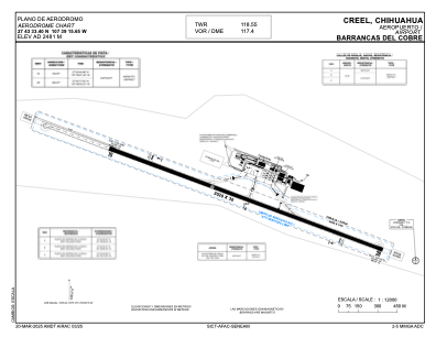


MMGA - Creel, Bocoyna Aeropuerto Barrancas Del Cobre
Located in Creel, Bocoyna, Mexico
ICAO - , IATA -
Data provided by AirmateGeneral information
Coordinates: N27°43'33" W107°39'16"
Elevation is 8140 feet MSL.
View others Airports in Chihushua
Operational data
Special qualification required
Current time UTC:
Current local time:
Weather at : - ( 0 km )
METAR: KNLC 171756Z 32023G31KT 10SM FEW180 26/07 A2984 RMK AO2 PK WND 29031/1734 SLP102 RH/32 T02610072 10261 20167 51001
Communications frequencies: [VIEW]
Runways:
| RWY identifier | QFU | Length (ft) | Width (ft) | Surface | LDA (ft) |
| 10 | 114° | 8268 | 98 | UNK | |
| 28 | 294° | 8268 | 98 | UNK |
Airport contact information
Address: Creel, Bocoyna Mexico