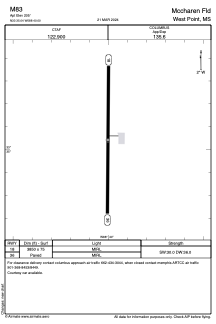


M83 - Mccharen Fld
Located in West Point, United States
ICAO - M83, IATA -
Data provided by AirmateGeneral information
Coordinates: N33°35'3" W88°40'0"
Elevation is 205 feet MSL.
Magnetic variation is 00° East View others Airports in Mississippi
Operational data
Special qualification required
Current time UTC:
Current local time:
Weather at : KGTR - Golden Triangle Rgnl ( 17 km )
METAR: KGTR 180556Z AUTO 06005KT 10SM CLR 23/22 A3003 RMK AO2 SLP175 60001 T02330222 10283 20228 403280228 58009
TAF: KGTR 180520Z 1806/1906 09003KT P6SM OVC250 FM181600 12013G21KT P6SM SCT030 BKN120 FM190000 11007KT P6SM SCT250
Communications frequencies: [VIEW]
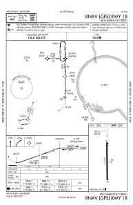
Runways:
| RWY identifier | QFU | Length (ft) | Width (ft) | Surface | LDA (ft) |
| 18 | 180° | 3850 | 75 | ASPH | |
| 36 | 360° | 3850 | 75 | ASPH |
Airport contact information
Address: West Point United States