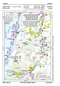
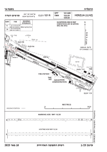


LLHZ - Herzelia Domestic Airport
Located in Herzelia, Israel
ICAO - LLHZ, IATA - HRZ
Data provided by AirmateGeneral information
Coordinates: N32°10'50" E34°50'5"
Elevation is 121 feet MSL.
Magnetic variation is 5° East View others Airports in Tel Aviv District
Operational data
Special qualification required
Current time UTC:
Current local time:
Communications frequencies: [VIEW]
Runways:
| RWY identifier | QFU | Length (ft) | Width (ft) | Surface | LDA (ft) |
| 10 | 0° | 2963 | 59 | ASPH | |
| 28 | 0° | 2963 | 59 | ASPH |
Airport contact information
Address: Herzelia Israel
