


LKTA - Tabor
Located in Tabor, Czech Republic
ICAO - LKTA, IATA -
Data provided by AirmateGeneral information
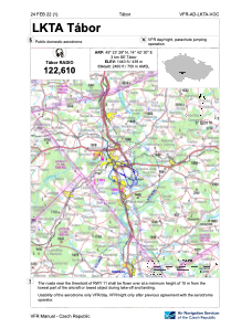
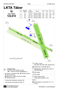
Coordinates: N49°23'28" E14°42'30"
Elevation is 1440 feet MSL.
View others Airports in South Bohemian Region
Operational data
Special qualification required
Current time UTC:
Current local time:
Communications frequencies: [VIEW]
Runways:
| RWY identifier | QFU | Length (ft) | Width (ft) | Surface | LDA (ft) |
| 11 | 0° | 3609 | 98 | UNK | |
| 29 | 0° | 3609 | 98 | UNK | |
| 16 | 0° | 2789 | 328 | UNK | |
| 34 | 0° | 2789 | 328 | UNK |
Airport contact information
Address: Tabor Czech Republic
