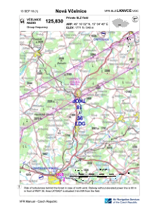
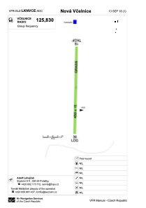


LKNVCE - Nova Vcelnice
Located in Nová Včelnice, Czech Republic
ICAO - , IATA -
Data provided by AirmateGeneral information
Coordinates: N49°16'2" E15°4'40"
Elevation is 1771 feet MSL.
View others Airports in South Bohemian Region
Operational data
Special qualification required
Current time UTC:
Current local time:
Communications frequencies: [VIEW]
Runways:
| RWY identifier | QFU | Length (ft) | Width (ft) | Surface | LDA (ft) |
| 18 | 1° | 1476 | 49 | GRASS | |
| 36 | 181° | 1476 | 49 | GRASS | 1476 |
Airport contact information
Address: Nová Včelnice Czech Republic