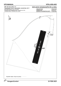
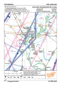


LHSS - Szolnok-Szandaszolos
Located in Szolnok, Hungary
ICAO - LHSS, IATA -
Data provided by AirmateGeneral information
Coordinates: N47°8'33" E20°11'47"
Elevation is 279 feet MSL.
Magnetic variation is 4° East View others Airports in Jász-Nagykun-Szolnok
Operational data
Special qualification required
Current time UTC:
Current local time:
Communications frequencies: [VIEW]
Runways:
| RWY identifier | QFU | Length (ft) | Width (ft) | Surface | LDA (ft) |
| 01 | 0° | 3937 | 656 | GRASS | |
| 19 | 0° | 3937 | 656 | GRASS |
Airport contact information
Address: Szolnok Hungary