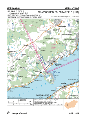
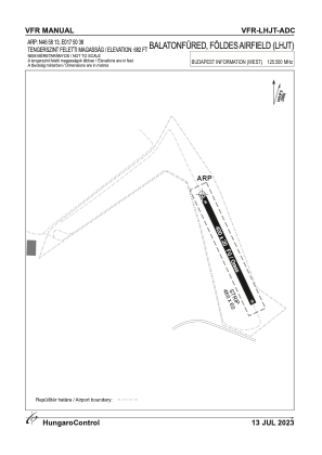


LHJT - Foldes Airfield
Located in Balatonfured, Hungary
ICAO - , IATA -
Data provided by AirmateGeneral information
Coordinates: N46°58'13" E17°50'38"
Elevation is 682 feet MSL.
View others Airports in Somogy
Operational data
Special qualification required
Current time UTC:
Current local time:
Weather at : LHPA - Papa ( 51 km )
METAR: LHPA 291045Z 33009KT 290V360 9999 FEW033 SCT200 22/12 Q1015 NOSIG RMK BLU
TAF: TAF LHPA 291115Z 2912/3012 32010KT CAVOK TEMPO 2912/2914 9999 SCT040 BECMG 2915/2918 VRB03KT
Communications frequencies: [VIEW]
Runways:
| RWY identifier | QFU | Length (ft) | Width (ft) | Surface | LDA (ft) |
| 15 | 0° | 1312 | 66 | GRASS | |
| 33 | 0° | 1312 | 66 | GRASS |
Airport contact information
Address: Balatonfured Hungary