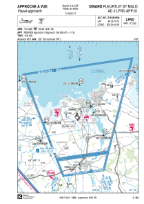
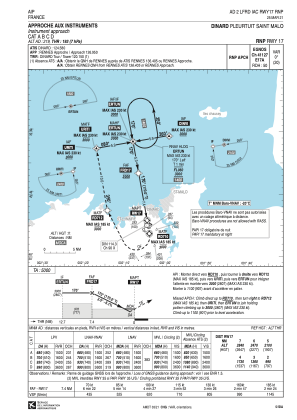
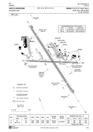


LFRD - Dinard Pleurtuit Saint Malo
Located in Dinard, France
ICAO - LFRD, IATA - DNR
Data provided by AirmateGeneral information
Coordinates: N48°35'16" W2°4'48"
Elevation is 219 feet MSL.
Magnetic variation is -0.36° East View others Airports in Brittany
Operational data
Special qualification required
Current time UTC:
Current local time:
Communications frequencies: [VIEW]
Runways:
| RWY identifier | QFU | Length (ft) | Width (ft) | Surface | LDA (ft) |
| 17 | 170° | 7218 | 148 | CONC+ASPH | 7218 |
| 35 | 350° | 7218 | 148 | CONC+ASPH | 7218 |
| 12 | 115° | 4741 | 148 | CONC+ASPH | 4741 |
| 30 | 295° | 4741 | 148 | CONC+ASPH | 4232 |
| 17R | 170° | 656 | 66 | GRASS | 656 |
| 35L | 350° | 656 | 66 | GRASS | 656 |
Airport contact information
Address: Dinard France
Handlers

Other aviation service providers
Aviation club (not for profit)

Aéroclub de la Côte d'Emeraude
Aéroclub de la Côte d'Emeraude
laurent.le.tynevez1@libertysurf.fr+33231082902
