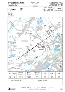


LFOG - Flers Saint Paul
Located in Flers, France
ICAO - LFOG, IATA -
Data provided by AirmateGeneral information
Coordinates: N48°44'59" W0°35'41"
Elevation is 663 feet MSL.
Magnetic variation is 0.11° East View others Airports in Lower Normandy
Operational data
Special qualification required
Current time UTC:
Current local time:
Communications frequencies: [VIEW]
Runways:
| RWY identifier | QFU | Length (ft) | Width (ft) | Surface | LDA (ft) |
| 05 | 54° | 2434 | 82 | ASPH | 1995 |
| 23 | 234° | 2434 | 82 | ASPH | 2434 |
Airport contact information
Address: Flers France
Fuel provider

Other aviation service providers
Aviation club (not for profit)

Aéroclub de Basse Normandie Flers/Condé
Aéroclub de Basse Normandie Flers/Condé
aeroclubdeflers.conde@gmail.com+33233659636
